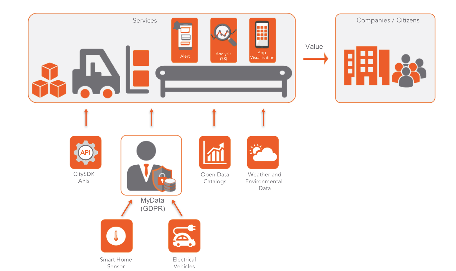
Urban Data Platforms are a major component in the digital transformation process of a city. They enable data-driven solutions to tackle current challenges in cities and communities. Thus, they form the basis for new solutions such as a route-planner or a digital twin. In such a platform, urban data are connected, analysed, and visualised. These data can be shared with city services or third parties and can be made usable for citizens via mobile applications. When the data platform is “open”, it is most usable and therefor a solution that helps cities digitise their services and connect them. One big advantage is that services and data can be connected more easily, and this enables improved digital services for citizens at lower costs.
An Urban Data Platform can be realised in different ways. Thanks to modular building blocks that are based on open standards, Urban Data Platforms can be adapted to the specific needs of a city.[1] Discover how the concept of Urban Data Platform is realised in the three mySMARTLife Lighthouse Cities of Nantes, Hamburg and Helsinki.
Open Specifications Framework – A set of Common criteria
The Cities of Nantes, Hamburg and Helsinki have developed their Urban Data platform following the same Open Specifications Framework defined within mySMARTLife. This Open Specifications Framework addresses four main issues: data interoperability, services interoperability, openness, and replicability. It enlightens the implementation and integration of multiple city domains (like infrastructures, mobility, energy, buildings) for smart management and big-data analytics. Its applicability is demonstrated in the three lighthouse cities.[2] The mySMARTLife consortium will soon test the level of interoperability between the three mySMARTLife Lighthouse Cities’ Urban Data Platforms.
Nantes: Urban Data Platform and the cross-modal observatory on mobility
As in other lighthouse cities, Nantes has adapted the platform to comply with the Open Specifications Framework and integrated new data and services. In Nantes, the Urban Data Platform lays on an existing framework for geographical data (GIS), and some other specific IT architectures. The project brought a major development on sensor data integration with the use of a comprehensive sensor data model (SensorThings[3]) at the core of the platform design. This extension was developed by Engie (Ineo Solutions Digitales). Currently, it is running different use cases with mobility and energy data and ensuring the monitoring of key performance indicators (KPIs) for the evaluation of different project actions.
Nantes: cross-modal mobility observatory
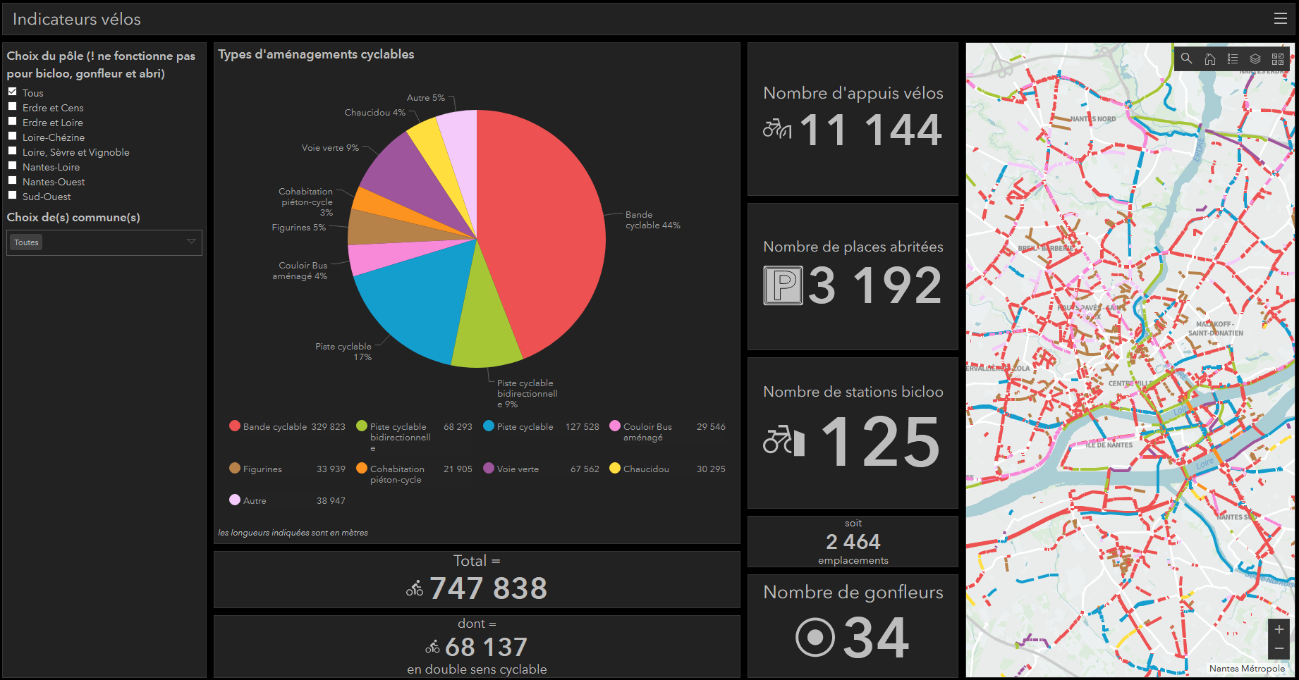
One major ICT action of mySMARTLife in Nantes is the cross-modal observatory on mobility. It aims at improving the overall capacity of delivering KPIs on mobility public policies. This task is the “tip of the iceberg” of mobility data management. This action included tasks such as switching to another GIS software, redesigning GIS infrastructure, collecting new field data, implementing data management, working on data standardisation, to finally offer dashboards with mobility policy KPIs.
Major improvements are data historicisation, data collection (field inventory), global access to KPIs, better appropriation of data through custom dashboards and synthetic infographic publication.
Hamburg: Urban Data – A vital part of everyday life!
Hamburg’s journey to becoming a Digital City is well underway: Digitalisation is on the rise in almost every part of the city. This has resulted in a wealth of data from various fields, such as supply and disposal, administration, health, construction, mobility, logistics, transportation and economy – but so far, they have not been linked to one another. The Urban Data Platform Hamburg aims to change that.
Based on a comprehensive concept, the Urban Data Platform allows users to quickly and efficiently integrate and interconnect urban data as well as standardised interfaces. IT systems and/or services in various urban areas can thus be connected in a way that enables them to recognise one another and automatically exchange data.
The data can be configured and evaluated individually via the Urban Data Platform and can be accessed in real time, depending on the user’s needs. Easy access to the data combined with their extreme topicality allow quick analyses at any time, which in turn aids quick decision making.
Available urban data sets are often intended to be shared with others. By importing these data to the Urban Data Platform, sharing is easy, uniform and machine-readable. Depending on individual applications, the data are filtered, new calculations are initialised and finally, the data are processed for visualisation on the map. Once this process has been completed, the platform provides interfaces that are accessible to all.
Further information: www.en.urbandataplatform.hamburg/urbanplatformhamburg-en/
Helsinki
In Helsinki, the Urban Platform evolved through several versions during the mySMARTLife project. In the latest stage, what started as an IoT platform became a data platform capable of processing and handling real-time data streams. The need for enterprise grade performance and usability became evident and because of this, the Urban Platform implementation is currently based on well-known and mature products such as Apache Camel, Apache Kafka and Snowflake data lake. The data is made available as data products on APIs to be consumed on various services, BI-dashboards and the city digital twin. The city has adopted the concept on its own platform and the first services have been integrated to use it on collecting water temperatures, usage of outdoor exercising equipment and the activities of utility tractors.
[1] Source: Urban Data Platform | Living in EU (living-in.eu) [as of 24.11.2021]
[2] https://www.mdpi.com/1424-8220/20/8/2402 [as of 24.11.2021]
[3] https://www.ogc.org/standards/sensorthings [as of 24.11.2021]


